Голодные игры
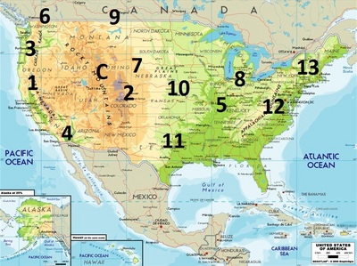
Голодные игры Panem map, based on the content in the Книги

|
senorbueno posted on Apr 09, 2012 at 11:10PM
There are several popular maps of Panem on the Internet. But they all seem to me missing some hints given by the author. So I came up with this map. This map is drawn based on the following "facts" given by those 3 books.
Capital is "surrounded" by districts. Thus it is not at the west side of Panem. We all know that it is in the Rocky Mountains, while the future east coast of North America cannot be to the west of Appalachian Mountains. And even with major disasters and wars, it will take millions of years for the North America to extent its west coast deep into Pacific Ocean, although a few miles of expansion is possible. As the result, to make Capital kind of surrounded by districts, if a district does not have a reason to be located to the east of the Rockies, I put it to the west of it. OK, now let’s start from those districts that probably are to the east of the Rockies. District 12: We all know that it is in the Appalachian Mountains. District 13: It’s behind D12, so it can be either New England, or Florida. As there are mountains, in which hovercraft hangers were dug, and pines so Katniss could make a pine needle pocket of Johanna, it must be New England. District 8: Textile can be produce anywhere. But it’s relatively close to D13, and Katniss could take a ride there from D13 and back easily. Most likely it’s next to D12, so Bonnie and Twill passed D12 boulder on the way to D13. District 7, 10: They are on the way between D12 and Capital, as Katniss wondered whether she was passing D7 or D10 on her first train trip from D12 to Capital. D7 is kind of to the north and Johanna’s home has a lot of pines. And to place D10, a livestock district, over the mid-west plain seems a correct choice. District 11: It is large, and to the south. And it can be arrived within one day by train, according to Catching Fire. There is no large landmass to the southwest of the Rockies, so it must be to the southeast of the Rockies. District 5: We all know that D12 produces coal. The main usage of coal is to generate energy, which happens in D5. Smart dictators like President Snow will not have the coal transported all the way across the continent to a power plant the west of Rockies. Also it makes sense for D5 to be close to D13, whose industry is nuclear. District 2: It’s on the way to the capital. The majority of rebellion force, as explained above, is located to the west of Rockies. And they met D2 as the last barrier to the capital. D2 is hilly and has a lot of quarries. So D2 is most likely also in the Rockies, to the south east of the Capital. Now, we have five districts left, 1,3,4,6, and 9. To make the capital surrounded by states, they must be to the west side of the Rockies, as least the majority of them. District 4: People there are fishermen, with skin exposed a lot, like Finnick. They produce seafood, thus must be on the coast. And it cannot be somewhere north, as there is no indication that Finnick caught cold a lot. Although it can be located next to the Gulf of Mexico, I put it south California and Baja California, to make it to the west of the Rockies. District 9: They product grain. Isn’t that a job for District 11? Anyway, as Saskatchewan is the No. 1 agriculture province of Canada today, it may be D9 in the future. District 1, 3, 6: Jewelry workshops, electronic factories, and transportation headquarters can be located anywhere. Among those three which one is to the north of which is unknown. But they must be to the west of the Rockies, as I explained above. By the way, the districts cannot take spiral shapes, as in one of those popular Panem maps, as it would be too costly to build fences between districts. They would be just block by block, divided by nature barriers as much as possible.
last edited on Apr 09, 2012 at 11:12PM
|
